WarViews: Static version
Click on the "+" sign in the top right corner of the map to toggle layer visibility. To pan, simply click and drag in the map area.
WarViews: Dynamic version
>>
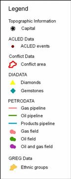
Datasets displayed
Conflict events: ACLED
Raleigh, Clionadh & Håvard Hegre, 2005. ‘Introducing ACLED: An Armed Conflict Location and Event Dataset’. Paper presented to the conference on "Disaggregating the Study of Civil War and Transnational Violence", University of California Institute of Global Conflict and Cooperation, San Diego, CA, 7–8 March.
Diamonds: DIADATA
Gilmore, Elisabeth; Nils Petter Gleditsch, Päivi Lujala & Jan Ketil Rød, 2005. "Conflict Diamonds: A New Dataset", Conflict Management and Peace Science 22(3): 257–292.
Oil deposits and pipelines: PETRODATA
Lujala, Päivi, Jan Ketil Rød, and Nadja Thieme. 2007. "Fighting over Oil: Introducing a New Dataset." Conflict Management and Peace Science 24 (3):239-56.
Ethnic groups: GREG
Cederman, L.-E., Rød, J. and Weidmann, N. B. (2007). "Geo-Referencing of Ethnic Groups: Creating a New Dataset". Paper presented at the 48th ISA Convention in Chicago, February 28 - March 3, 2007.